Sunday 5/20/2012
 |
| On our last day in Lake Tahoe, we decided to just take a walk on a sidewalk that is right along the lake in South Lake Tahoe. There is this monument in a picnic/ beach area. |
 |
| In the middle of the monument, it has a picture of the lake and the names of towns, mountains, and points of interest around lake Tahoe. |
 |
| On the ends, there are tiles that have kids paintings on it. |
 |
| Me walking Mallery along the walkway. |
 |
| Beach below the walkway. |
 |
| Looking west in the picnic area above the beach. |
 |
| Looking east in the picnic area. |
 |
| Beach below picnic area. |
Monday 5/21/2012
 |
| As we drove on Hwy. 28 on the east side of Lake Tahoe, we saw this hardy guy riding his bike with his gear on it. |
 |
| Shortly after that we saw this guy also. He is fit, but not as hardy as the previous guy. |
 |
| A shot of the most beautiful lake I have ever see, as we travel north. People ask us all the time, what our favorite place is on our travels. For me, Lake Tahoe has to be one of those favorites! |
 |
| When we reached the north west corner of Lake Tahoe, we took Hwy. 267 north. We climbed out of the basin that Lake Tahoe sits in. We climb about 1000 ft to an elevation of about 7000 ft. |
 |
| Then we lost most of that climb when we reached the top and started back down. At the top we had a 9% grade down for 5 miles. |
 |
| Near the end of that 5 miles and around this curve, we came upon road construction. |
 |
| Joe almost didn't get stopped in time for this road construction! We were going 50 mph downhill when we came upon all these cars completely stopped. Yiks! |
 |
| At the bottom, we came into a valley, with snow capped mountains in front of us. |
 |
| We came to the outer skirts of the town of Truckee, CA., |
 |
| and crossed over the Truckee River. ( The only out flow of Lake Tahoe) |
 |
| We than got on I-80 and headed SW. |
 |
| On I-80 we climbed again out of the previous valley to the top of snow capped mountains. |
 |
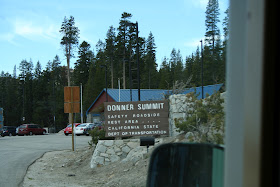
| We stopped at the Donner Summit rest stop area at 7,231feet for lunch. |
 |
| We wanted to go to Donner Pass, but when you are as big as we are and don't know the parking situation, it's best to pass for another day. |
 |
| After lunch, we continued down the west side of the Sierra Nevada range on I-80. |
 |
| After about 25 miles on I-80, we turned northwest on Hwy. 20, |
 |
| and soon crossed into Nevada county, in California, |
 |
| After driving along a ridge for some time, we came to our new neighborhood, Harmony Ridge Resort which sits at 3,400 feet. It is located just outside of Nevada City, Ca. |


No comments:
Post a Comment