Monday 10/7/2013
 |
| Our RV Park in Vonore, TN. gave us a close proximity to Hwy. 129. We wanted to see Fontana Lake, and Hwy 129 was the shortest route to the lake. Hwy.129 follows the Little Tennessee River. |
 |
| With the Smokies in the distance. |
 |
| Just before we entered the 11 mile Dragon (name of 11 miles of Hwy. 129), we came to the small village of Tallassee and a Harley Davidson store. |
 |
| The store is a good place to get stickers, pins, patches, and T-shirts proving you were on "The Dragon". You can also get gas there. |
 |
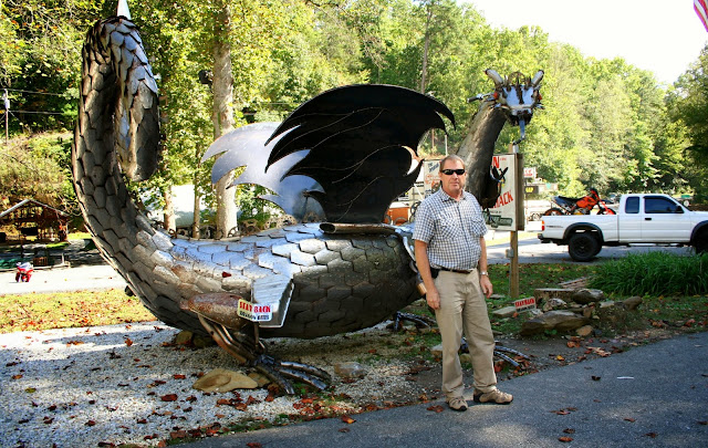
| This sign was posted next to the dragon statue. How true this sign is! |
 |
| After a couple miles on "The Dragon", we came to this overlook and view of Chilhowee Dam on the Little Tennessee River. |
 |
| On the rock wall of the overlook, everyone had left their signature. |
 |
| Across the road was this guard rail lined with thousands of stickers. |
 |
| Beyond the rail is the views of the Smokies. |
 |
| We got back into our car and continued "The Dragon". No guard rails and steep drop off, and we were on the outside of the road! |
 |
| We cross into North Carolina while still on "The Dragon". |
 |
| As we neared the intersection where the road spits to Hwy. 28 or Hwy. 129., we came to the Deals Gap Motorcycle Resort. |
 |
| Across the street from the resort we found the Tail Of The Dragon store that had this dragon in front of it. |
 |
| This dragon tail was also in the parking lot of the Tail Of The Dragon. |
 |
| At the end of the tail is a motorcycle wrapped in it. |
 |
| You can get T- shirts, stickers, pins and patches of "The Dragon" at the Tail Of The Dragon store. |
 |
| Across the street is the Deals Gaps Motorcycle Resort. |
 |
| At the intersection, we took Hwy 28 toward Fontana. |
 |
| We passed the Twenty Mile road that was closed that enters into the Great Smoky National Park, because the government was still shut down. Sure glad this was not on our agenda. |
 |
| Hwy 28 followed the Little Tennessee River toward Fontana Lake. |
 |
| We found a small pull out park along the river and made a stop. While at the park, we met another traveler with his dog and he told us that two motorcyclist died the day before on US 129. |
 |
| We arrived to the Fontana Dam area next. |
 |
| View of Fontana Lake which is a reservoir impounded by the Fontana Dam of the Little Tennessee River. |
 |
| The lake water levels are lowered in the fall with the anticipation of late winter and early spring flooding. |
 |
| Fontana Lake is 17 miles long and forms the southern border of the Great Smoky National Park and the northern border of the Nantahala National Forest. |
 |
| The volunteers at the Fontana Dam and Visitor Center confirmed the motorcycle fatalities on US 129 the day before. |
 |
| Fontana Dam is the highest dam east of the Rockies at 480 feet. |
 |
| View of the Little Tennessee River from on top of the dam. |
 |
| Aerial picture of a picture of Fontana Dam and Fontana Lake. |
 |
| In the Visitor Center I had another traveler point on the map where Fontana Lake was. (Joe was off gabbing with the Visitor Center volunteers). |
 |
| Fontana Lake 's water level fluctuates 50 feet by the controlling of the dam. |
 |
| The Visitor Center had this picture of a mama bear and her three babies crossing the Fontana Dam lawn. |
 |
| On the way home we stopped at Harbour Place, the housing community across the lake from us. |
 |
| Toqua Camp Ground across the lake. |
 |
| A little closer of the view of Toqua Camp Ground across Tellico Lake. |
 |
| Can you see our Nest (third RV from the lake). |
 |
| As we drove down a hill through the community to the entrance or exit, we started to get a great view. |
 |
| The homes on this upper level of the neighborhood have this stunning view of the Smokies. |
 |
| We cross the bridge to get on the other side of Tellico Lake to get back home and saw another stunning view to the southeast of our park. |
 |
| Tellico Lake continues east of our campground as we travel toward it on Hwy 360. The total drive for the days was 103 miles. |


No comments:
Post a Comment