Monday 6/11/2012
 |
| We left Point Cabrillo Light Station, just north of Mendocino, CA., and continued north. Just up from the light station is the Caspar Beach RV Park. |
 |
| It is directly across from a beach cove. |
 |
| I checked Mallery in the back seat and she looked like she might take a nap. It had been a long day for her. |
 |
| In a few minutes she was up again. She normally naps off and on during the day. When she goes with us on day adventures, she has a hard time getting her naps in. |
 |
| Fort Bragg has a population of 6,963, and had a lot of business. It is the main business district for this coast area. |
 |
| Hwy. 1 followed the coastline off and on for the next 25 miles. |
 |
| Note the home on the cliff point. |
 |
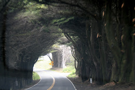
| The highway took us through a grove of trees. |
 |
| It started to mist at this point. |
 |
 |
| As we drove I saw these big black birds on the utility wires. I had Joe turn around so I could get a picture of them. |
 |
| There was no place to stop on the Hwy., so I had to get the picture on the fly. I believe they are Turkey Vultures. |
 |
| As we continued our drive the fog seemed to get worse. |
 |
| We went past the Westport Beach KOA, just north of Westport Beach State Park. |
 |
| At the top of a hill we looked down at the KOA on a little beach cove. |
 |
| There were a couple of tenters on the beach. |
 |
| Further up the road was the Westport Union Landing State Park Campground. |
 |
| After the 25 mile drive going north up the coast on Hwy. 1 or Shoreline Hwy., the road turns east. |
 |
| There are no highways along the coast from here to Eureka, CA., only secondary roads. |
 |
| Hwy. 1 connects and turns into Hwy. 101 at Leggett, CA, going north or south. |
 |
| Unfortunately Hwy. 1 from the coast to Leggett is just as curvy, and slow back to Hwy. 101. This is a view when we reach the highest point on Hwy. 1or Shoreline Hwy. |
 |
| South Fork Eel River Bridge built in 1944. |
 |
| The tree is the Chandelier Tree, which is privately owned in Leggett, CA. It is a redwood tree, and stands at 315 feet tall, and is at least 2400 years old. |
 |
| The price was $5, which I thought was well worth being able to say, Joe, Malley and our Honda drove through a redwood tree. |
 |
| Our Honda had plenty of room. |
 |
| There was a small crowd that watched as cars drove though. Someone in the crowd said," Oh look the dog is watching too, as they drives through the tree". |
 |
| This SUV had a much tighter fit as he drove through the tree. |
 |
| There is a gift shop also at the Chandelier Tree, if you have time to browse. |
 |
| The drive from Leggett, CA. south, to our campground on the north side of Willits, CA., was another 24 miles. |


Would have loved to see your pictures/comments about Willits as am considering moving there! Enjoyed all the others, and Mallery, too. Thanks
ReplyDeleteHi Anonymous, I remember we drove into Willits and walked around and stopped at a shop or two. If there is anything about the town it would be a blog written before this one. God Bless on your decision whether to move to Willitis or not.
Delete