|
| Dave and Renee dropped us off at the subway and we took it to downtown Boston. It cost $1.75 each to get to the downtown. We took the red line and needed to remember that so we would get back to Medford. We had wished we had gone the day before because it was a lovely day. The forecast was to be a perfect week while we were in Boston, but the weathered changed, and we woke up to a rainy day. We found our way to the start of the Freedom Trail located on Tremont Street and the Boston Common. The Boston Common is the 1st stop and is the oldest park in the country. If you don't like history, you may not enjoy this trail, but come along anyway. We all need to learn something new ever day. |
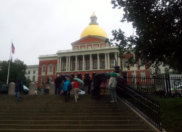 |
| You can take a self guided tour or a guided tour of the trail. We came upon a guided tour in front of the capitol. We didn't know it was a guided tour at the time and stood and listen to the guide talk. The State house was built in 1789. The dome was originally covered in wood shingles, but now is cover in copper and 23 karat gold to prevent leaking into the State House. |
 |
| You follow the Freedom trail by following the line of red bricks or a painted line. We followed the guided tour and when they got to the 3rd stop, we stopped and listened again. At the 3rd stop, we were told that he was a paid guide and we were more than welcome to join in and pay him later at the end of the tour. We accepted and continued the trail with the guide and paid customers. |
 |
| The 4th stop was at Granary Burying Ground. This is the 3rd oldest cemetery in Boston. |
 |
| We were told about the stone markers. The skull with wings represented death and the wings taking the soul to heaven.Religious marking of any kind were not allowed under British law. Often times, bodies would be dug up and moved to make more room in the cemetery. The skull was laid on top of the rest of the body's bones, thus the skull and crossbones sign. |
 |
| This was Paul Revere's original head stone. |
 |
| As time went on, the public felt he deserved a more proper monument, so this now stands for Paul Revere. There was another couple that had joined like us for a few stories, and then were told the same thing we had been told. They decide to forgo the fee and left our group. |
 |
| There are about 2300 head stones, but 5000 to 8000 bodies buried here. Because of the cost of burials, there use to be one stone per family. The Boston Common and the grave yard use to be maintained by cattle. With the advancement of the mower, the headstones had to be rearrange so a mower could be easily used between the stones. Now the stones are not where the bodies or families are. |
 |
| This is one of the oldest streets in Boston. The other thing I remember our guide told us was that Benjamin Franklin use to walk up this street everyday to go to school, until he dropped out. Yes, he didn't like school and he dropped out. I am not sure at what age, but that's what we were told. |
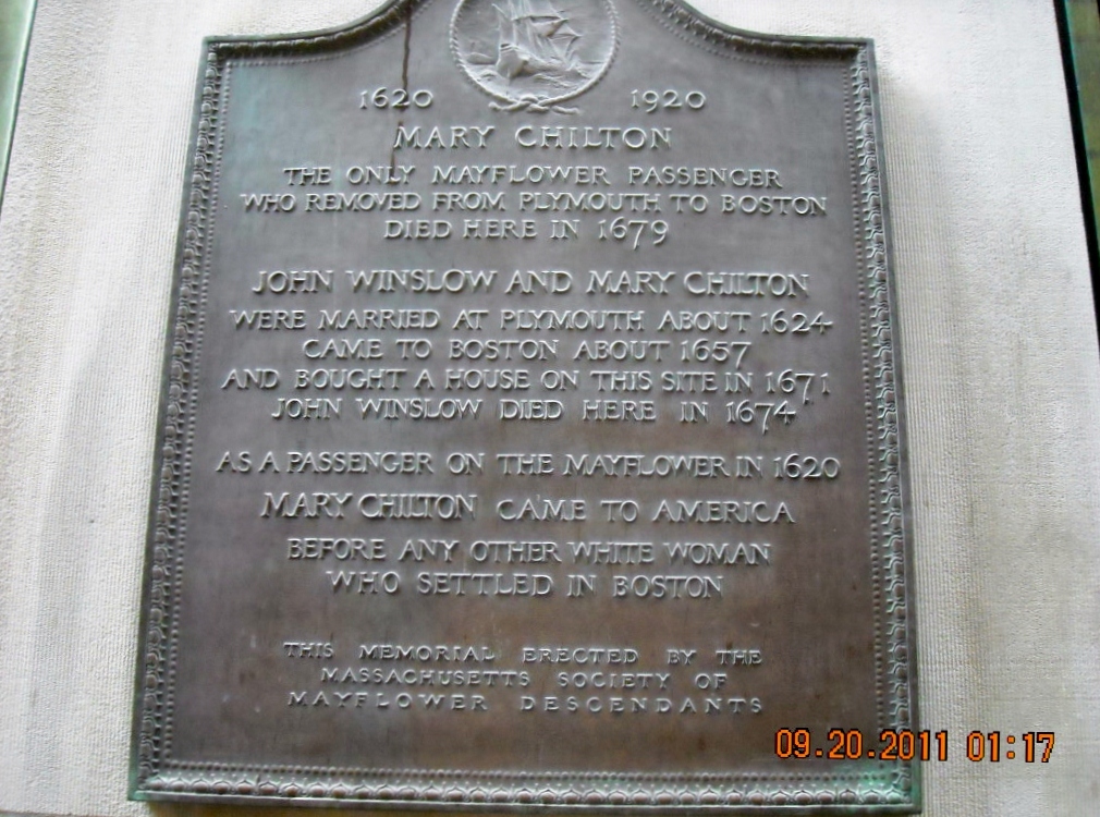 |
| This is a plaque that was on a wall on one of the buildings.We were told that Mary Chilton is believe to be the first women to step off the Mayflower at age 13. Further research told me that her parents died the first winter in the new world. She had brothers and sisters, so it is thought she was in the care of them. |
 |
| This is the Old State House that sits among the town's new modern skyscrapers. |
 |
| This Georgian style building dates back to 1713, and was the center for all political affairs and debates. |
 |
| It is also the site where the Boston Massacre erupted from. It is now the Old State House Museum. |
 |
| Not only was it drizzling but it was getting cold out. |
 |
| At this point the guided tour ended and we were on our own, after Joe paid him $24.00. I think we would have been better to leave like the other two did at that price. We had brought our lunch and we asked our guide where would be the best place to go to get out of the rain, and sit and eat. He told us there were tables in the center court of the Quincy Market. |
 |
| The Quincy Market was full of people but we found what I guess you would call standing tables that had shelves. It was a place you could put your food down on and stand and eat. It was great to get out of the rain, but my feet were tired and I could have used a seat at that moment! |
 |
| After we ate Joe needed the restroom. We were told there was one up stairs. We went up, but there were no restroom, but there were more tables, a few empty one's at that. Everything is a learning thing. For any of you who are going to Boston's Freedom Trail and stop at the Quincy Market, there are table upstairs, and you won't have to stand on your weary feet. |
 |
| Above the tables were old signs decorating the old stone walls. |
 |
| Another suggestion, don't bring your lunch, there are ton's of interesting things to eat at the Quincy Market. |
 |
| Everything you can imagine, is there to eat.I was going to get an Italian ice cream for desert after lunch, but the girl who waited on me was so rude, I changed my mind. The lady in the picture got some while I wait for Joe to return. Then she comes over by me, and I asked her if the lady was rude to her. She said yes, but the Italian ice cream was good! |
 |
| Outside the Quincy Market is a nice shopping district, but no time for shopping, so we looked for the Freedom Trail to continue our walk down history lane. |
 |
| View of the shopping court from the other end. I did manage to sneak into a couple of shop, while Joe used a restroom. |
 |
| We continued the trail away from the main downtown area, so we could look back at the high rising buildings |
 |
| As we walked down the street, we noticed the three clear rectangular shapes, and wondered what they were. |
 |
| But first we wanted to check out a park that we had crossed the street to see. Below the tree lined cement benches, |
 |
| was stadium like seats or steps. It looked like a place where concerts were held. Later when we got home to Dave & Renee's, they told us that the building behind the stadium/steps was the Boston City Hall. I looked on a map and this area plus a few other buildings is called the Government Center. Dave and Renee said it was not used for concerts and was basically useless. I read some information on the internet with a statement about the City Hall Plaza. It said, " All the nearby buildings seem to be facing away, making the plaza's 11 acres (45,000 m2) of concrete and brick feel like the world's largest back alley. … [It is] so devoid of benches, greenery, and other signposts of human hospitality that even on the loveliest fall weekend, when the Common and Esplanade and other public spaces teem with Bostonians at leisure, the plaza stands utterly empty save for the occasional skateboarder…" (Wasik 2006, 61) The plaza is often colloquially referred to as "the brick desert." |
 |
| We then walked across the street and found that the rectangular glass column was the Holocaust Memorial. |
 |
| A group of survivors made Boston their home. With over 3000 peoples help, this memorial was erected in 1995. Six million numbers are etched into the glass in a orderly fashion, to represent the Jewish people who were given numbers by the Nazi before their death. At night they are lit. In my internet search it states there are six glass columns, that represent the menorah, of memorial candles. I looked back at my pictures, and it only shows three of them. There must be three shorter ones. |
 |
| Further on the Freedom Trail we came to the Bell in Hand. The Bell in Hand claims to be the oldest pub in the United States. Jimmy Wilson who had been the town crier for fifty years was the first owner of the tavern. |
 |
| He only served ale. Everyone from lawyers, politicians, and journalist came to this place for a good time. |
 |
| Daniel Webster stopped by from time to time also. |
 |
 |
| The Union Oyster House is just down the street from the Bell in Hand. |
 |
| Daniel Webster was also a constant customer of the Union Oyster House on Union St.. |
 |
| There are 16 official sites on the Freedom Trail. Some I have spotlighted and others, are just sights along the way. If you want to hear about all 16 sites, you will have to come and do the trail. |
 |
| As we crossed one street on the trail we saw these embedded vegetables and newspaper . Not sure what it was about, but interesting. |
 |
| Another look back at the down town area as we walk further away. |
 |
| We enter into part of the Rose Fitzgerald Kennedy Greenway. |
 |
| Boston has been removing their elevated interstates systems that went through the downtown area. The interstate system was not working for the area anymore, so they decided to but the interstates that went through the downtown area underground, which is called the Big Dig. |
 |
| This park is where the old interstate ran, and is part of a connecting park system from cement way to green way. |

 |
| From the park, we can see one of their major bridges. |
 |
| The downtown looked nice with some green in the foreground. I like their idea to add green to a big city. |
 |
| The Freedom Trail is a 2.5 mile walk, and I was getting hungry. Italian ice cream at just the right place at just the right time, and the server was polite! I had not ever heard of Italian ice cream, until we came out east. The first time I saw it, was in a store. I bought some and it tasted like ice cream to me. I had to ask someone, how it was different. Italian ice cream is made from milk , not cream, so it is less fattening. I am not sure about calories or carbs yet. I will have to look into that matter later. To be continued : We arrived in Toledo, Ohio today, and are staying at another Wal-Mart Supercenter. We stayed two nights in Buffalo to see Niagara Falls. It has been difficult blogging, because with out electricity, my batteries run low pretty quickly. |