RVery Best Nest

Come join Joe, Mallery & I, as we travel around the USA in our RVery Best Nest. God's Favor has been chasing us down, and we are enjoying all of His blessing's, that He has created for all to enjoy!


Friday, September 30, 2011

Nubble Light House, Cliff Path, Fort Foster, Whaleback Light & Portsmouth Harbor Lighthouse

This is a view of Short Sand Beach in York, ME. This was our first stop for that day. We walked around York Beach village for awhile. The village was pretty dead, and a few shops were closed. We were told, on the weekend things would be busy again.

The beach is deep, but pretty short.

A view of Short Sand Beach from the side.

We stopped at Nubble Light House in Cape Neddick, ME.


The light house is on Nubble Island.


Notice the white basket  hooked to wires. This is how the light keeper gets back and forth to the island.

Off to the north there was a crowd of people watching something in the water.

There was a rescue team practicing in the ocean.


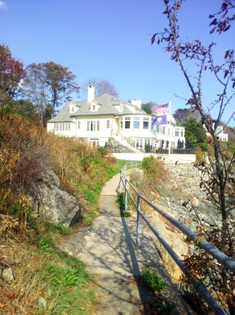
Off to the north of Nobble Light House was a huge home or resort.

I zoomed in to get a better view of the home/resort.

Joe told me that when I win the lottery, I could build a place like that, so the place would be big enough for our family. I told him, I could do that when I win.

Long Sand Beach is just beyond Short Sand Beach in York.

We checked the ordinances for Long Sand Beach. Dogs are allowed on the beach before 8AM and after 6PM on a leash. They can be off the leash for exercise during that period. Dogs are not allow on the beach between those hours during the day, from May 20th to September 20th.  No beach walking here with Mallery that day. I didn't want to walk there anyway, because it was low tide and it really was stinky smelling as we drove by.

Just south of Long Sand Beach is the Cliff Path, north of Harbor Beach in York Harbor.

The sign said no dogs were allowed on the trail, so I got out my dogie Kangaroo pouch and put Mallery in it.

Signs at the beach stated" parking pass "were needed, so we parked as far up the road as possible, since we didn't have a pass and hoped we wouldn't get a ticket.

The Cliff Path is not maintained well and is pretty rugged in many places.

Some places it is not paved and a bit rocky.

If you have good hiking shoes, you could climb down to the water at low tide in some areas.

The path ends at a fence to someones back yard on the coast.

I am not sure how long the path is. I could not find information on the internet on it's length. It probably was about 1/2 mile. But since you have to turn around and go back, the path might be a mile in total.

The trail ends back at Harbor Beach.

Above Harbor Beach is a park.

In the park, this memorial is erected for those on or  lost at sea.

On the memorial below the light house it says' "..... Oh Hear Us When We Cry To Thee For Those in Peril On The Sea......." 

We left Harbor Beach and headed south to Fort Foster Park in Kittery, ME.

Fort Foster was closed, so we parked and walked into the park.

Map of Fort Foster Park.

We walked into the park and walked up the stairs of Fort Foster. View north toward the pier.

Below the fort is a picnic area.

Looking out toward the southeast at Portsmouth Harbor Lighthouse on New Castle Island, New Hampshire.

With a zoom in you can kind of see a white conical shape across the water.

Joe's little boy inside him decided to play fort for a while.

After Joe got done playing we walked out on the pier. This is a view of the fort in the upper middle of the picture.

Close up of the fort. You can see at the top where Joe was playing war in the top of the fort.

This is a view of  Kittery, ME. to the south.

View from the pier.

View of Whaleback Light in the distance in Kittery, ME.

At the end of the pier, there is a large deck.

In four of the corners of the deck, there are old ship tie up posts.

An old building out from the pier on an island. I did some research, but could not find out any information on it.

Another view of Portsmouth Harbor Lighthouse on New Castle Island, NH.

Close up of previous picture.

Another view of Whaleback Light out from the fort pier. It stands 50 feet tall.

While we were out that day we saw this campground located on the ocean. Joe stopped to get prices.

The front row sites are pricey,  $89 a day. The campground is located on Hwy 1A in York Harbor. Pretty pricey for full timers, but I bet it's nice on a  hot summer day!
,

Thursday, September 29, 2011

Wood Island Light, Biddeford Pool, & Fortunes Rock Beach, ME.

We enjoyed another lobster dinner at home. These lobster didn't seem as red as the previous lobsters.

The next days drive was north again, from our Moody Beach Campground. We drove to Biddeford, ME. In Biddeford we took Hwy. 208 passed the University of New England.Once we passed the university, we took a left onto Hill Beach Road.
       
The road ended with homes at the point. We turned around and found a small pull out spot that lead to Hills Beach.

There were people sitting on their deck to the right of the small beach. We hoped we were not on a private beach.

Joe zoomed out to Woods Island, to see Woods Island Lighthouse. You can just see it if you look just to the right of the big sailboat's main mast.

While he was taking pictures I walked on the beach in search of sea glass.

Out straight from the beach was another island. It looked pretty private with homes on it.

As we left the point, I saw this home on the bay side of the point. I love this home with it large wrap around porch. A sign on the porch read, " Between Waters Cottage 1880.

As we drove back down the peninsula, we spotted an accesses roads between the home to Hills Beach, but there was no parking area. (There were a sign stating - no parking on access road, and a private beach sign on the beach) We pulled down one of the access roads, where there was a sign for a home for sale. We parked for a second to get another view of the island with the homes on it. If we could have found a parking spot, we could have walked on the sand bar out to the island. There was someone jogging out to it, when we took the picture.

Another close up, of the island with the homes on it.

As we walked back to the car I took one final picture of the island with the sea grass on this side of the shore.

We left the Hills Beach Peninsula and drove around the bay to Hwy. 208. Hwy. 208 takes you out another peninsula called Fletcher's Neck to the coastal village of  Biddeford Pool. Out on the end of Biddeford Pool, we drove on Ocean Ave. These were some of the home across the street from the ocean with great views.


On the north side of  Biddeford Pool Peninsula or Fletcher's Neck, we could see across the channel to Beach Hills Point where we had been earlier that day. The channel leads into what is called the, " The Pool". It is a large body of water surrounded by the two peninsula's. It is a six mile tidal pool inlet, that is surrounded by tall grass salt marshes. It is considered to be one of the premier birding spots on the NE coast. 

Looking north from the village of Biddeford Pool.

We could see Wood Island Light from this point also. The Wood Island Light is located just 2 miles east of the mouth of the Saco River and 1 mile north of the village of Biddeford Pool. 

The Stage Island Monument ( tall column on the island in the picture) is a day mark that can be seen near Wood Island.

View of Wood Island Light from Fletcher's Neck. The light stands 47 feet.

Right up from the channel point on Lester B Orcutt Boulevard, is the shop called "Between The Tides. I was going to go in and look around, but we were too late in the season, and it was closed during the week. In the fall it is only open on the weekends.

"Between The Tides" shop is located in the lower half of the basement of this home.

Just up the street from the, " Between The Tides" was the Pool Lobster Co.It also advertised serving food and groceries. While I was going to visit the shop, I asked Joe to go and get me a cheese burger at the Pool Lobster Co. I had not brought much to eat that day and was getting hungry. Joe came back and told me they only serve food on weekends after labor day. The village of Biddeford Pool goes to sleep during fall week days.

We left Biddeford Pool and drove south on 208 to Fortunes Rock Road. We found a parking spot on the road next to an access path to Fortunes Rock Beach. The parking spot looked like it belonged to a rental home on the beach, but the rental home looked unoccupied. ( We hoped.) We walked out to the beach for a walk. Looking north toward Biddeford Pool, ME. point.

Close up of previous picture.

There were a few people on the beach down south of where we started our walk.

September 15, was the official day that dogs could be on the beach during the day. During prime season, they can only be on the beach before 8AM and after 6PM. It was September 14th, so we took the chance, and took Mallery out with us.

She ran back and forth between Joe and I, as I walked closer to the water. Joe stayed farther up because he had regular shoes on.

She ran and ran chasing shore birds. She loved this beach because it was soft with no shells and just a few rocks,  that were more in toward the shore.

Look Mom and Dad, no feet on the sand!

It was a great day for Mallery, because it was not too hot and we had a great breeze.The temperatures were in the mid to low 70's. Look at her chase birds as big as her.

We came to a fisherman digging holes all around him.

I asked him what he was digging for, thinking he might be digging for clams. He told me he was digging for sea worms to fish with.

Wish you all could  h ave been here, and enjoy the peace of a quiet beach.

We love the cooler weather, because we are not sun bathers or sitters.

We headed back to the car, hoping it was still there and not towed away or with a ticket.

Car still there and no ticket, we drove to the end of Fortunes Beach so I could get a medium rock from the rocky shore at this end of the beach. We didn't realize it, but there was free parking at the end of Fortunes Rock Beach, where you don't need to worry about being towed away or get ticketed. Hope this helps someone out there going to Fortune beach.

On the way home we drove on one more small peninsula on Sea Spray Drive off Granite Point Rd. Not much to see here except homes on a loop drive at the end of the peninsula. This is a view of  Horseshoe Cove off of Sea Spray Rd.