


 |
| After our hikes and dinner that day, we left to go catch the 7PM sunset cruise we had scheduled earlier that morning. We were told by the ticket lady to get there early, because people started to line up early. We had planned on getting here by 5:45, but some how we didn't arrive until 6:15, and the line was still a mile long. This man and lady were the first in line, and I asked her what time she got there to be first in line. She said they were there at 4:45. The cruise didn't start till 7PM! |
 |
| I walked half way down the line and took this shot so you could see just how long the line was. Joe is way at the end of the line in the white shirt wavying his hand at me. By the time we boarded at 6:45, there were 1/3 more times this many people behind us. |
 |
| Unfortunately we missed being on the top deck by about 10 people. Two boats had been scheduled because of the high reservation numbers. As we left the port I took the picture of the water clarity, and a view of Grand Island. |
 |
| On the mainland shoreline I took a picture of a home that is for sale, that we had picked up a flyer for earlier that day. The white story and a half home had a asking price of $265,000. The price isn't too bad for being on Lake Superior. The lot was smaller than what we are looking for, so we had called the realtor and looked at another lakefront home which I blogged about in my previous blog.. |
 |
| Our boat captain took us over to Grand Island past the Grand Island East Channel Lighthouse. The light was used from 1868 to 1908. Because it sits on private property, it can only be seen from Lake Superior. It is one of the most photographed lighthouses on the Great Lakes. |
 |
| Next we pass the sand bar between Grand Island and the east shoreline of the mainland. |
 |
| We were told that you can be walking in the water that is around a foot or 2 deep on the sand bar and suddenly it is 50 feet deep. Watch that step if you don't know how to swim! |
 |
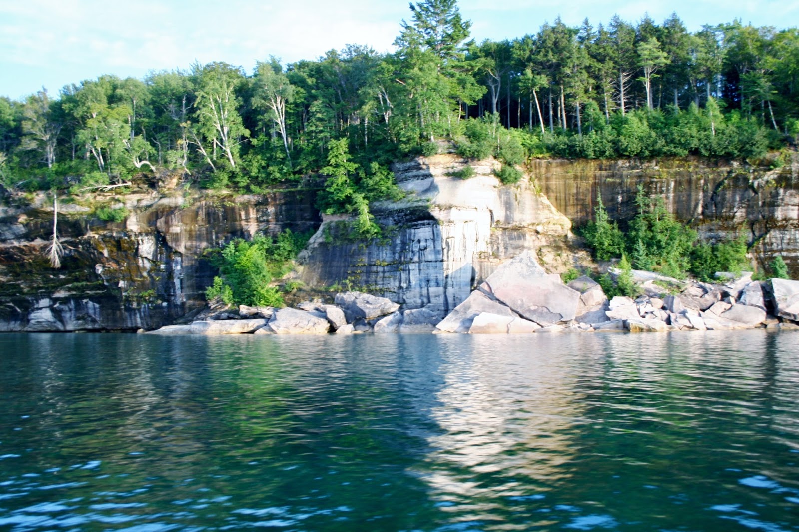
| As we enter into the Pictured Rocks National Lakeshore, we started to see some color. Everyone was taking tons of pictures, and our captain told us to save some of our battery power for what was further up the way. |
 |
| This is Miner's Castle. You can drive to this point, but you will not really see the rock formation from the deck on the rock. |
 |
| Though there is another platform further south of Miner's Castle that probably gives you a better view of it. |
 |
| As we turned the corner of Miner's Castle, we could see the people and upper deck better. |
 |
| Bridalveil Falls is but a trickle during the summer. |
 |
| Painted Coves |
 |
| The color is created by groundwater and spring rich with minerals such as iron, copper, and lime that leak out of the cracks in the rock and trickle down it's face. |
 |
| Then we came to the best part as far as I was concerned. |
 |
| Stripes of colors though the cracks and down the rock. |
 |
| Just amazing! |
 |
| I couldn't decide which was better so I posted this and the last picture. You decide. |
 |
| Rainbow Caves |
 |
| I saw some pictures on the internet that people took looking out from the caves. You can also take a kayak guided tour from Miner's Castle, which if we ever get back this way, I would definitely do. |
 |
 |
 |
| Lover's Leap |
 |
| The water is only 2 feet deep below Lover's Leap, so unless you have a death wish, it is not advisable to jump off it. |
 |
| More bands of stripes of color. |
 |
| Pictured Rocks National Lakeshore is 15 miles long. |
 |
| We see a cruise boat that is identical to ours, but going the opposite direction. They must have been the 6PM tour. |
 |
| Rainbow Cave |

 |
| This rock formation was called something but I have forgot it now. If you know, please leave a comment. |
 |
| I also saw some pictures on the internet taken from the trail that were pretty spectacular. ( especially the ones taken in the fall with the fall colors against the caribbean blue waters of Lake Superior) |
 |
| Indian Head |
 |
| A close up of Indian Head. Do you see his head and feathers? |
 |
| Grand Portal |
 |
| Grand Portal as we pass by. |
 |
| Grand Portal from the other side. |
 |
| Leaving Grand Portal. |
 |
| Battleship Rocks. As you round this first formation that looks like the bow of a battleship you see a line of about six more just like the first on down, symetrically lined up as if ready to pull out of port together. |
 |
| Flower Vase - the trees are the flowers coming out of the vase formation rock. |
 |
| Indian Drums |
 |
| The water is this color in true life. Just gorgeous! |
 |
| All of a sudden I looked and said to Joe, " Where the heck are we going?" |
 |
| The water was at least 10 feet deep if not more and we could see the bottom. |
 |
| Our captain took us just inches from the wall. |
 |
| Looking up to the people on the upper deck. |
 |
| Looking into the water and seeing a lower rock shelf. |
 |
| Looking up as we go under the rock edge top. |
 |
| This is Chapel Cave that our captain had just drove us into. While we were going into it, I heard a little girl cry to her mother she was scared, over and over until he backed out. |
 |
| Chapel Rock |
 |
| The sandstone that supported the root system of the tree on Chapel Rock collapsed approximately 40 years ago. Chapel Rock is now an island (when water is high) with only the lifeline of the trees roots to the mainland. |
 |
| As we head back toward our boarding spot, we see another boat go into Chapel Cave. |
 |
| If you are sitting on the left side of the boat, you get the good picture views going back. |
 |
| I ran to the top deck and tried to get a couple different shots. This one was another shot of the water clarity and seeing the rock formation below the shoreline. |
 |
| Our captain took us so close, the passengers on the upper deck could almost touch the rock walls. |
 |
| View of how close the boat came to the wall on our return trip. |
 |
| We pass Lovers Leap one more time. |
 |
| Our captain was very young, (probably in his twenties), and very informative and funny! |
 |
| If you took all the water in Lake Superior and fill it in a pool the size of the United State, the pool would be 5 feet deep. (One of the many interesting things we learned on the cruise). |
 |
| We saw a couple sitting in one of the Rainbow Caves on the way back. There is a trail that follows the Painted Rocks National Shoreline that many hikers do and camp out on one of the three pristine beaches that can only be reach by hiking. |
 |
| The Painted Rocks National Lakeshore is on the list of "Top Ten Hidden Gem's" |
 |
| Half of our boat ride back to the starting point was enjoyed with the sun setting. |
 |
| We got back to shore at 10PM. Luckily our campground was just about five minutes west of the boat launch, so we didn't have to drive too far in the dark. (Joe and my night vision is not so good anymore). It was hard enough to know where to turn into our campground, because the campground sign is not lit up at night. One reason we seldom get home after dark. If you are in the Upper Pennisula, the Painted Rocks Cruise is a must do, even at the $36 a person fee! |
Beautiful pictures... I will have to add that to our bucket list for when we get out to that part of the country.
ReplyDeleteThank you Rick, It is a definite bucket list site!
DeleteThis was my first time to your blog. The pictures are beautiful. I have never been in this part of the country and I think it will have to be put on my bucket list for sure. Just beautiful. I do not have any of the accounts that are listed. I will have to post under anonymous. Hope you open it. I do not know how to get one of the accounts.
ReplyDeleteThank you Anonymous,I would love to go back in the fall next time.
Delete