


Saturday 9/14/2013
 |
| After visiting the Point Betsie Lighthouse, we drove south a few miles to Crystal Lake. |
 |
| Crystal Lake is located about 25 miles SW of Traverse City, MI. It is 8.11 miles long, 2.5 miles wide and has a surface area of 9,8545 acres. The average depth is 70 feet with a maximum depth of 165 feet. |
 |
| We found a public dock to see the water clarity, which was about like most northern lakes in Michigan- clear! |
 |
| As we walked back to the car I noted this sign. It made me wonder, as I remember when I waded out into Lake Superior, I remembered that my legs itched around my ankles and calf's that night. Maybe this is what causes it. I would never think, a large lake like Lake Superior would have this problem, but I guess if Fowl swim along any lake shore, this could develop. |
 |
| A nice home across from the lake with a large screened in lower and upper porch. |
 |
| As we drove around the western part of the lake I saw this home with a grass roof. How does that work? |
 |
| But what really caught my eye was this goat statue on the grass roof. |
 |
| Again you can see the line where the bottom of the lake drops off, and the aquamarine colored waters. |
 |
| As we headed home, we made a quick stop at Loon Lake. |
 |
| Loon Lake is in the Sleeping Bear National Lakeshore Park, and is a small 100 acres lake. |
 |
| The lake had at least 9 fishing boats on it, so it must be good fishing for it's size. Check out the fishing gear on the kayaks. |
 |
| The next day we drove north from our resort, instead of south. Joe made a stop at a overlook on Hwy. 677, just south of Glen Lake. I posted this picture, not because the overlook was that great, but to show how we were just starting to get splashes of color from our cool nights. Mid October, this overlook should have awesome views of color. Lake Michigan off in the distance. |
 |
| Next on the agenda was to see Glen Lake. Glen Lake has two parts to it, Little Glen and Big Glen. |
 |
| Little Glen sits below Sleeping Bear Dunes. |
 |
| We took this picture of Sleeping Bear Dunes from the north shore of Little Glen. |
 |
| After exploring Glen Lake a bit, we drove west to Hwy M-109 to the entrance of Sleeping Bear Dunes National Lakeshore. We had to pay $10 to get in because we had not bought an annual National Parks Pass this year. This was our first National Park for a while, and don't have any plans to visit another in the near future. |
 |
| A covered bridge starts the 7.5 mile Pierce Stocking Scenic Drive loop. |
 |
| First stop is the Glen Lake overlook. Little Glen lake is the closest lake in the picture, with Big Glen lake out in the distance. The lakes are separated by a narrow channel and crossed by Hwy. M-22 bridge. |
 |
| View of the north shore of Little Glen. Little Glen has a surface area of 1,415 acres. It is much shallower with a maximum depth of 12 feet. Big Glen Lake has a maximum depth of 130 feet, and a surface area of 4,871 acres. Sand from Sleeping Bear Dunes has been blowing into the lake, causing to become shallow. It use to be as deep as Big Glen Lake at one time. |
 |
| Our second stop is an overlook of the sand dunes and Lake Michigan to the west. |
 |
| Shot of Lake Michigan and one of the Manitou Islands north of the dunes. |
 |
| This picture shows how close Little Glen Lake sits in reference to Lake Michigan in the distance. |
 |
| Views of the Sleeping Bear Dunes and Lake Michigan and one of the Manitou Islands. |
 |
| Our next stop on the loop drive is the one that everyone comes to see, but first a short climb up a small sand dune path. |
 |
| Be prepared for a view that will knock your socks off. Pictures just don't do it justice! |
 |
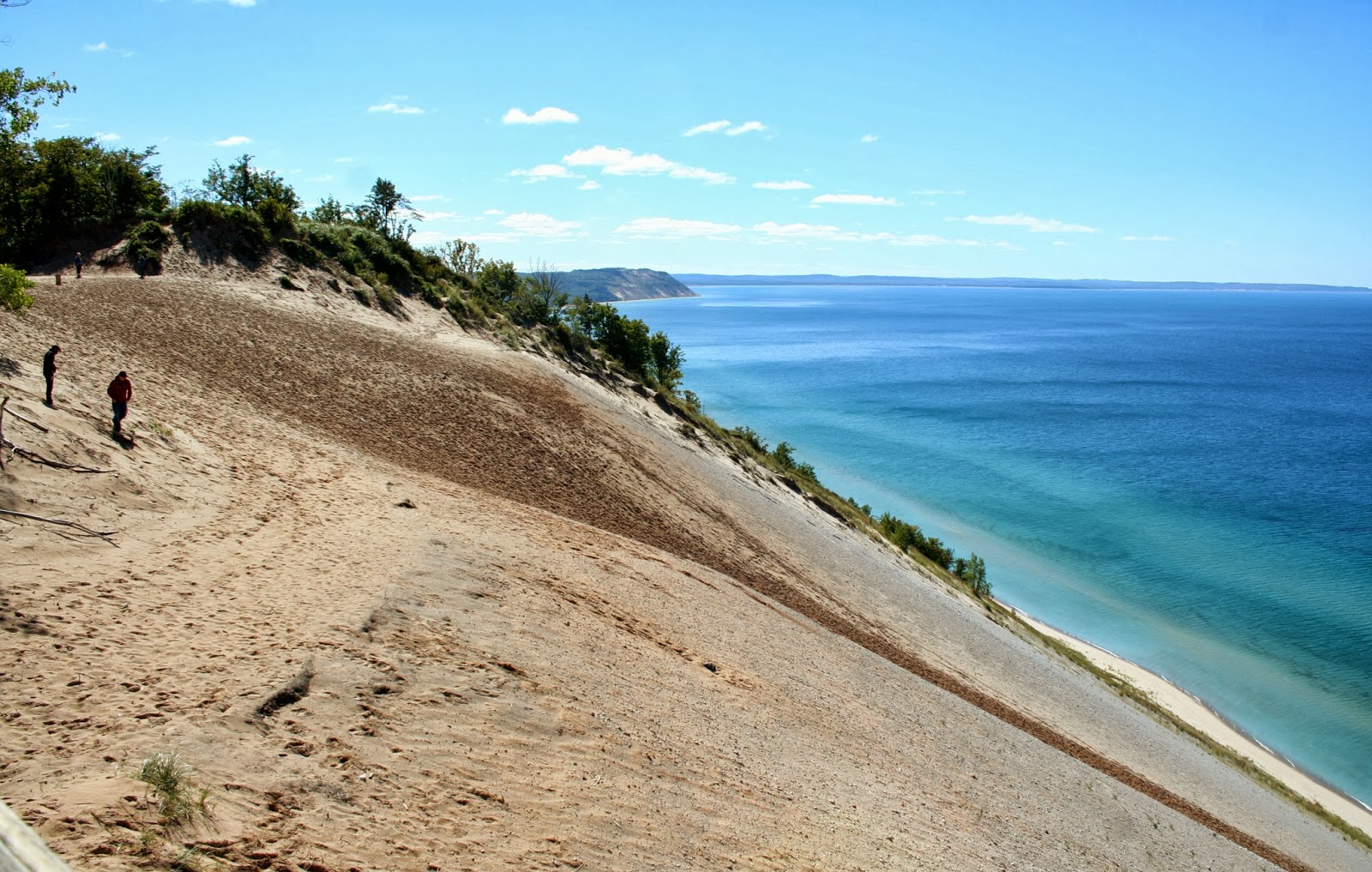
| We see this sign that tells us that the sand dune is a steep eroding bluff and may cause injury or illness, and rescue fees will be charged. OK, we don't get any closer. |
 |
| Up the hill we found a bridge platform that allows views without danger of injury or health risks (from climbing back up the hill). The platform stand 450 feet above the Lake Michigan. |
 |
| View from the platform looking north. South Manitou Island in the distance 10 miles away. It's hard to tell from this picture, but the slope is extremely steep to the lake. |
 |
| View across dunes to the north. |
 |
| Another view down the steep dune slope to the beautiful waters of Lake Michigan. |
 |
| With the zoom lens I was able to get a picture of a lighthouse on South Manitou Island. |
 |
| If you have time while visiting Sleeping Bear Dunes National Lakeshore, you can take a ferry to South or North Manitou Islands. |
 |
| It was a perfect cool but sunny day to get the best views at the Lake Michigan Overlook. Wisconsin is 54 miles to the west, but because of the curvature of the earth we can not see it. |
 |
| View to the south of Empire Bluff, 4 miles away, from the platform. |
 |
| I had to take two pictures to get the whole view of the steep slope and path people have taken down the sand dunes and back up. No body was climbing the dunes the day we visited the park, but my brother in law told me when they came here, they watch several people doing the climb, and it seemed to take hours. |
 |
| We walked back down the hill from the viewing platform. |
 |
| View of some people contemplating the climb. |
 |
| The pictures just don't give you the same vastness you see in real life. Like we always say, you just have to see it with your own eyes to really appreciate the wow moment you come over the the hill. We have seen some really wow things in our travels, and this one will always stick in my mind as one of them. |
 |
| Do we try it or not is their question of the day. For us it was a definitely not! |
 |
| After the last stop, this stop is just kind of a ho hum! But I posted it because it shows how a one time bay is becoming a closed off lake. (stated by a near by sign). |
 |
| Close up of North Bar Lake. |
 |
| And now with the zoom lens. The blowing sand has slowly built a wall that turned the bay into a lake. South Bar Lake (you can not see this lake in this picture) has completely closed the channel to Lake Michigan from the blowing sand. |
 |
| Views looking south from the North Bar Lake Overlook. To be continued: We arrived in Berea, Kentucky today, and are staying our 3rd and final night at a Super-Wal-Mart. The traffic on I-75 has been really heavy with semi-tractors like I-80, especially when we had to go through Cincinnati, Ohio. Joe had to slam on his breaks twice, because a couple stupid people pulled in front of him. The last one pulled in front of him and then slowed down real fast because they thought a semi was coming into their lane. People need to know big rigs CAN NOT stop quickly like a car, and THEY are endangering themselves when they pull in front of semi's and motor homes! We wish we were back in Northern Michigan, because our 5PM temperatures inside our Nest is 84 degrees! |
No comments:
Post a Comment