


Friday 10/4/2013
 |
| While still in Heiskell, TN., we decided to go see Douglas Lake. We are in search for the perfect lake to live on while also exploring United States. The Douglas Dam was the closest area of the lake to access it. (Note the campground across from the dam- we visited it a little latter) |
 |
| TVA ( Tennessee Valley Authority) is the largest nation's public power producer and steward of the Tennessee Rivers. |
 |
| Views of Douglas Lake and Dam from an overlook area. |
 |
| Joe points out the location of Douglas Lake. The red slashes mark all the dams in the area. |
 |
| Here Joe points to Norris Lake, which we visited in previous blogs. Norris Lake has two arms of the lake. |
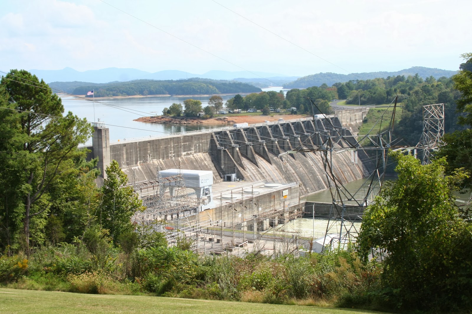 |
| The Douglas Dam is 202 feet tall. |
 |
| We cross the river below the dam and found the Mountain Cove Marina. The clarity of the water in the lake is about 5 feet deep, but the water has more of a green color. |
 |
| Just down the road from the marina, we found the Mountain Cove Campground. The campsite sits on Douglas Lake and has sites for RVs between 30 to 60 feet long. The sites have electric and water, and a dump site in the park. |
 | |
|
 |
| When we got into the town of Sevierville, the traffic got heavy and slowed way down. |
 |
| We saw the Titanic (again), |
 |
| and King Kong. Are we in Branson, MO.? |
 |
| No, but evidently the same companies that are in Branson are also here in the Sevierville/Pigeon Forge area. |
 |
| As we approached Gatlinburg, we took the Gatlinburg By Pass to avoid more traffic. |
 |
| At the first overlook we got a view of Gatlinburg. I love this little town, but we just didn't have time to shop. ( This is our 3 time to the Smoky Mountains and Gatlinburg). |
 |
| View looking east of Gatlinburg. |
 |
| We drove up the road a bit further to another overlook. Another view of Gatlinburg looking west. An information plaque tells us that records show that during the last half of the 20th century, the visibility in the Smokies has decreased by 40% in the winter and 80% in the summer due to pollution. It has been 5 years since we were here last and we didn't remember the space needle tower. |
 |
| Joe said he wouldn't like to go up it anyway! |
 |
| To the east of the lookout we saw this house sitting on what looks like trees. Is it a tree house? |
 |
| Wow what a view they must have, but I don't know if I would feel comfortable in a house on a ledge like that. |
 |
| We continued up the road though the Smokey's. |
 |
| The higher we went, we started to see more yellow. |
 |
| Newfound Gap. |
 |
| View of the road we were just on. |
 |
| I heard someone say that the ridge in the distance is the Blue Ridge Highway. |
 | |
|
 |
| We wanted to go to Clingman's Dome, |
 |
| but it was closed due to the government shut down. The only reason we got to see what we did is because the road is a major highway from Gatlinburg, TN to Cherokee, NC. We headed back down toward Gatlinburg. Once through Sevierville, we took another route on Hwy. 441. |
 |
| This route was suppose to take us through Knoxville, but there was a detour so it took us around the downtown area.Our total drive that day was 135 miles. |
No comments:
Post a Comment