


Friday 10/11/2013
 |
| Our campground was just down the road from Hwy.64/74 that we wanted to explore. Our first stop was at the Ocoee No. 1 Dam. |
 |
| Joe points to the map of dams and where we were at. The map shows about 28 dam in the TVA (Tennessee Valley Authority watershed). |
 |
| Ocoee Lake is 7.5 miles long and has a shoreline of approximately 50 miles, and nearly 2000 acres. |
 |
| We stopped at a state park to get better view of the lake. Most of the land adjacent to the lake is managed by the US Forest Service as part of the Cherokee National Forest. |
 |
| As we continued east on Hwy. 64/74, we follow the Ocoee River. This river is used a lot through the summer for kayaking and canoeing. |
 |
| A little further east we came to Ocoee No. 2 Dam. |
 |
| The boat ramp below the dam. This area is way too low for kayaking now. |
 |
| We continued our drive, and went past the site of the 1996 Olympics. It was barracked up, so we couldn't stop and check it out. A whitewater canoe slalom course was constructed here for the Summer Olympics in Atlanta, Georgia. It is so expensive to run, that only the commercial rafting industry uses the course in the summer. |
 |
| Because the Ocoee River above Dam 3 rarely has water in it the Whitewater Center which is operated now by the US Forest Service, serves primarily as a site for hiking and mountain biking with over 30 miles of trails. The river upstream of Dam 3 that comes from Georgia is called the Toccoa River. You can see the dry river bed in the picture. |
 |
| The Boyd Gap Scenic Overlook is where many of the trails start. In this picture we were looking south toward Georgia. |
 |
| After Boyd Gap Scenic Overlook, the two lane highway has an occasional passing lane. |
 |
| Once again we enter into North Carolina. |
 |
| Just south of the town called Ducktown, we turned north on Hwy. 68. I kept seeing signs for the "Field Of The Wood", and wondered what it was. As we were driving by, we decided to check it out. |
 |
| On the gate we saw this plaque. "Gates With Thanksgiving" Psalm 100:4 |
 |
| Entrance into the Field Of The Wood. |
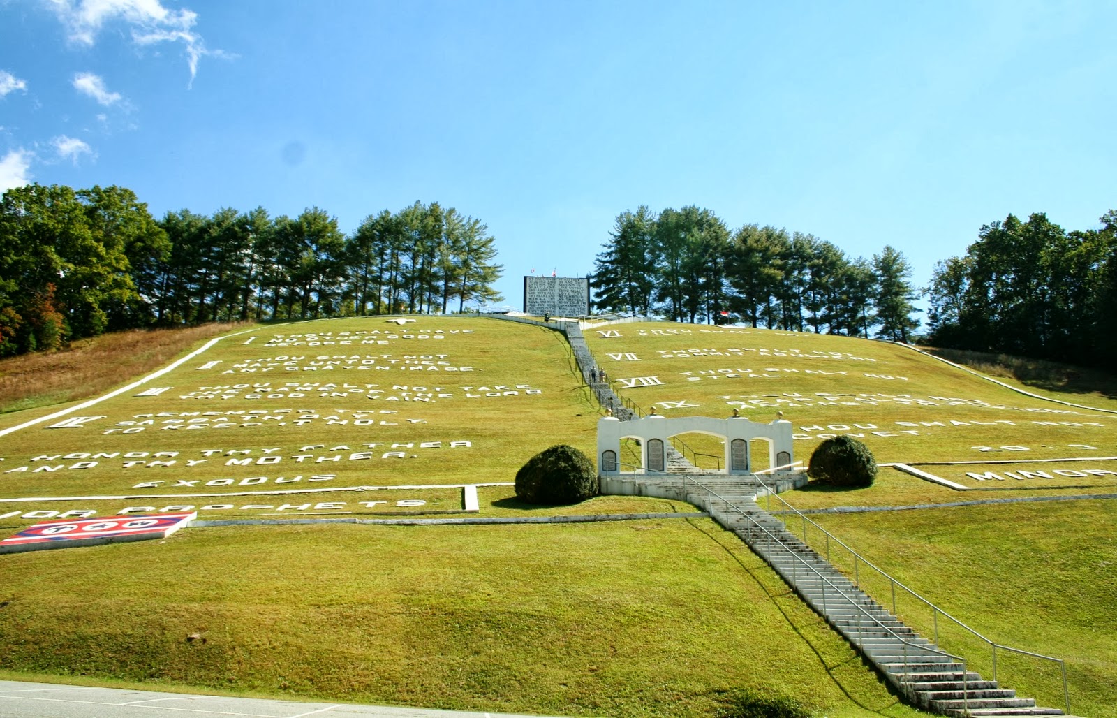 |
| As we pulled in I look up the hill, and said "it's the Ten Commandants"! We thought this was a good place for lunch, so we ate while we watched people climb to the top. |
 |
| Across the street, was another hill with steps. After lunch we decided to get some exercise. |
 |
| The sign tells us it is the Prayer Mountain. |
 |
| More plaques with scriptures on the entrance arch to the Prayer Mountain. |
 |
| As we climbed the Prayer Mountain, we got a better view of the "Ten Commandments" across the way. |
 |
| The other scripture on the Prayer Mountain entrance arch. |
 |
| Above the entrance arch, stairs lead us past monuments with more scriptures. |
 |
| Each monument had a state name at the bottom. |
 |
| I was glad we stumbled on this place. As Joe said, "This is right up your alley"! |
 |
| We started back down the mountain, so I took another picture across the way from a higher perceptive. |
 |
| Joe pointed out the Witness Tree that he had read about while I was reading other scriptures. |
 |
| This is the tree that had the church banner on it, that was later struck by lightning. |
 |
| Because the day was getting short, instead of taking the time to climb the stairs to the top of the Ten Commandments, we drove our car up the road to the top. |
 |
| Joe and Mallery sit next to the two most important commandments, that sits above the Ten Commandment. |
 |
| If you want, you can climb a few more stairs in the building to get above the two most important commandments. |
 |
| From here, you can see above and beyond the Prayer Mountain. You can also see the baptismal pool, |
 |
| and a good view of the bushes that were trimmed to say, "Jesus Died For Our Sins" When we were below and walked past the bushes, we had not noticed what it said until we came to the top of this mountain. The property also has a gift shop, and cafe that is open on just specific days. |
 |
| We drove further up the hill and found "The All Nations Cross". The cross represents the cross that Jesus was crucified on. "He did not die for only one nation... but that also he should gather together in one the children of God that were scattered abroad". John 11:52. The church is to go out and teach all nations. When a nation receives the Gospel, the church of God is established there, another flag pole is placed on the cross and the flag of that nation is displayed. |
 |
| This was the view from the "All Nations Cross". |
 |
| After we left the Field Of The Wood, we continue our drive to see Hiwassee Lake, Unfortunately because the government was shut down, the road that took us to the lake was closed, and time was running out to go any further to see the lake. We took Hwy 294 that looped back to Hwy 64/74 and headed back toward home. |
 |
| Hwy. 64/74 was a four lane highway back to Ducktown. We enter back into Tennessee. |
 |
| Once past Ducktown the Hwy went back to it's 2 lane road, which is very curvy with large 18 wheelers and lumber trucks coming around the curves. One of the reasons, I would not want to live on a lake in the Appalachians is I hate all the curvy 2 lane roads! I was disappointed we didn't get to see Hiwassee Lake, but I was really glad God led us to the Field Of The Wood. It is a place I will never forget! |
No comments:
Post a Comment