


 |
| About 10 miles north on Hwy. 9 from Magic Pines Campground, is the Ausable Chasm. Rainbow Falls is in the picture above. During a wetter season, the falls would also be on the other rock to the left from Ausable River. |
 |
| Down the trail is Elephant Head carved by mother nature, through a unique erosion process. The elephant stands 100 feet high. |
 |
| After the Elephant Head the trail takes you across the Ausable River for the rest of the trail. |
 |
| The gate keeper takes your ticket here. Adult fee is $16, 5-12 is $9, 5 and under is free. |
 |
| Throughout the trail, there are signs about the different trees in the Adirondack. |
 |
| If you get bored with the tree information, just skip it, but I took pictures for reference for me. |

 |
| This information is for the Hemlock. |
 |
| We look back across the chasm to where we were when we saw the Elephant Head. If you pay a little more you can take the stairs down across the chasm to some falls and a cave. The business was working on the dam, so the falls were not open that day. |
 |
| A look back at the bridge we had just crossed. |
 |
| Rainbow Falls is the most photographed waterfalls in the Adirondack. This is what the falls looks like in the spring. |
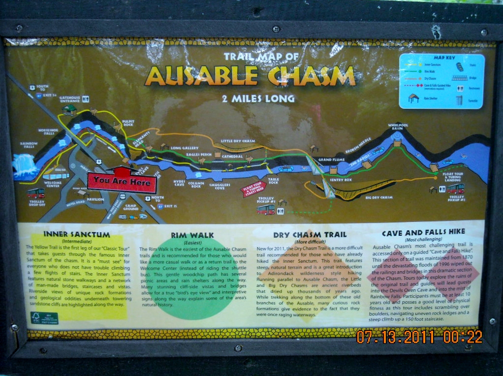 |
| Here is a map of the 4 different hiking routes of the chasm. |
 |
| The deer like this tree in the winter. |
 |
| Some of the trail is boardwalk. |
 |
| The Ausable Chasm. |
 |
| Some of the trails are dirt and rock with railings. |
 |
| These steps are very narrow, and I hit my shin, when I came up them. OUCH! |
 |
| This part of the trail has been discontinued. It was partly destroyed during one of the many floods. |

 |
| This is what is called a pothole. It is 6 feet in diameter, |
 |
| and 20 feet deep. Jacob's Well is far above the current river, so it is not effected by erosive effects anymore. Looks like it has become a wishing well now. |
 |
| While on the trail, watch your step, because the rock is uneven. |
 |
| and very narrow, in some places. |
 |
| Some of the trail is a sea floor that was brought up from a fault line. |

 |
| Can you see the face in the rock. I didn't see it until I was taking this picture. |
 |
| Did you see it? If not, I'll give you a hint. The large nose and a upper lip. |
 |
| I dared Joe to cross the river on the tree trunk, to get to the rafting boats ahead. |
 |
| Joe wouldn't cross the log, so we used the narrow bridge to get closer to the raft boats. |
 |
| For $10 extra, you could take a raft trip down the river. |
 |
| The rafts are lowered down to the river. |

 |
| We didn't go on the rafts, because the ride was rated very mild, that day. |

 |
| This walkway to the raft table is on a cable that can be lifted up during flooding times. |
 |
| A raft is being lowered in this picture. |
 |
| This is the first rapids, after the raft leaves the table. |
 |
| We were on a bridge looking down the chasm, before the raft comes through. |
 |
| There goes the raft. |
 |
| The raft has a guide at the back of the boat. |
 |
| Close up of previous picture. |
 |
| In this picture you can see where the river was narrowed, to create more rapids. |
 |
| Paper Birch Trees |

 |
| After you raft down the river, for $5 more, you can be taken back to the table, and tube down the river. |

 |
| This explains why they needed to make the cement walls for the rapids, and more about the past. |
 |
| We made it to the end of the trail to catch the bus back to the start. |
 |
| The rafts and tubers end their ride down below. |
 |
| More history if you are interested. |
 |
| The bus dropped us off back at Rainbow Falls. You can walk back on the trail, but a storm was coming, with lighting and thunder off in the distance. |
 |
| Power Station |

 |
| At the end of the tour you are guided into the gift shop and restaurant. We dodge the food and gift shop, and as we walked out to the car it started to rain. |
 |
| On the way home, Joe saw this church at the top of the hill in the town of Keeseville, NY. |
 |
| The video below is of the tubers going through the rapids created by the built up narrowing cement. |
No comments:
Post a Comment