


 |
| From the summit of Cadillac Mountain, we made a couple stops, as we drove back down.. |
 |
| Half way down I just had to take a few more pictures of the Porcupine Islands. |
 |
| It was clear where I took this shot, but fog still around the islands. |
 |
| In this photo, you can barely see the islands. |
 |
| We planned on coming back up to the summit of Cadillac Mountain on a clear day. Unfortunately there was just too many other things to do and we never got back up. |
 |
| View toward Eagle Lake and Sargent Mountain. |
 |
| Our next stop on Acadia National Park loop road was Sand Beach. |
 |
| Along the rocky shore of Acadia National Park, there is only one sand beach. |
 |
| Swimming is only for the hardy, because even on a warm summer day the waters may be a chilling 50 degrees. There were a couple kids braving the water. |
 |
| No dogs on the beach, but I went down a few steps to get the last two pictures. |
 |
| Behind the the parking, I notice hikers climbing the mountain. I saw others watching them also. |
 |
| The trail is very steep, with iron rungs on ledges of exposed cliffs. The trail is categorized as strenuous. Definitely not a trail for us. |
 |
| There is also a trail that takes you along the shore, called, Ocean Path, up from Sand Beach.. It is categorized as easy, with uneven ground, but fairly flat. |
 |
| We did this trail, but on another day. Back to the loop drive. |
 |
| After Sand Beach the loop drive takes you along the rocky shores. |
 |
| There are many pull out stops for views and pictures. |
 |
| I believe this is Otter Point. |
 |
| I think by looking at the maps, this is Otter cove. The tide was out and there were people digging for clams. |
 |
| Walking on the rocks, was very tricky and slippery. |
 |
 |
| At the cove there was a bridge letting the water into a lake area. |
 |
| The lake on the other side of the road. The rose in the picture is a wild rose, that you find along salty water. I was told the small red/orange tomato like fruit, that also grows on the bush is made into a jam, called wild rose hip. |
 |
| Hunter Head view, at the south end of Acadia loop. |
 |
| As we approach Jordon's Pond, cars lined the road for quite a distance. As we walked to Jordon Pond restaurant we walked past this house. I think it is called the Gatehouse. |
 |
| There is also a trail that goes around Jordon's Pond, that is located behind the restaurant. |
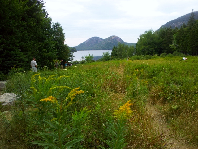 |
| View behind the restaurant. There are wild blueberry bushes between the restaurant and the pond. If you are lucky, you may find one or two, because everyone that passes the field picks and eats them as they go by. I found a few very small blueberries, and ate my first wild blueberries here. |
 |
| Jordan's Pond with Bubble Mountain in the distance. |


 |
| On the back lawn of Jordan's Ponds Restaurant, there were many people enjoying dinner or blueberry popovers and tea. I had just ate a afternoon snack before we arrived, so I decided I would have to wait to have a blueberry popover next time. |
 |
| As we left the restaurant, I took a picture of the free shuttle that you can take all over Desert Island. It has a bike rack on the front of it, so you can put your bike on it also. |
 |
| There are seventeen stone-face bridges that link the carriage road system. The roads are used by horse drawn carriages and bike riders. There are 45 miles of the carriage road throughout the park. |
 |
| Bubble Pond Bridge. |
 |
| After driving the loop, we stopped at Acadia National Park Visitor Center to get more information on where the trail heads were for the trails. |
 |
| A pretty tree outside of the Visitor Center. It looks like a Pyracantha brush and berries, but it is a tree. If anyone know the name of this tree, please leave a comment with it's name. |
 |
| A model of Desert Island and Acadia National Park in the Visitor Center. |
No comments:
Post a Comment