Friday 6/15/2012
 |
| The camp host at Klamath River RV Park told Joe about this trail that takes you past the river and then to the ocean. |
 |
 |
| As we walk along the trail, we notice a sign asking visitors to respect the Yurok Indian's ceremony land and buildings. |
 |
| Looks like the area had not been used for a while. |
 |
| It was extremely windy that day, and sand was blowing at us. Not much fun! It tends to be windy in this area. |
 |
| We spotted the seals, and Joe headed for them. He looked back for me, |
 |
| I was checking out rocks and drift wood. |
 |
| The Klamath River is the second largest river in California that runs about three hundred miles from Oregon to the Pacific Ocean in Klamath. |
 |
| Joe stopped and waited for me, before going any closer. |
 |
| As we walked up closer, they all started to dash for the water. |
 |
| We backed way up, and they calmed back down. |
 |
| I sat on the ground and inched myself closer and closer on my bum every 3 minutes or so. All eyes were on me |
 |
| I couldn't believe how almost every seal kept an eye on me the entire time! |
 |
| I was using my zoom to get these pictures, so I was not that close |
 |
| Even on my bum, when I got about 50 yards away, they headed for the water |
 |
| At that point I backed up and they calmed down again. |
 |
| The water in this small bay was very clear. |
 |
| Klamath River is world famous for Chinook Salmon and Steelhead fishing. |
 |
| As we walked back to the trail, I said to Joe, "Look someone is snorkeling"! Joe said it was a stick. |
 |
| I zoomed in and took a picture. After I uploaded this pictures, I decided Joe was right. |
 |
| Just up from the trail we found a pull out and parked the car. |
 |
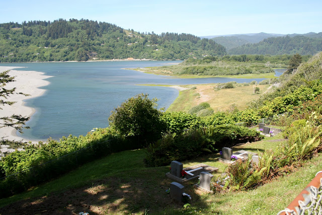
| We got a great view of where we had just been walking. |
 |
| The river flows from the upper right, out to the ocean at the upper left. There was a small cemetery below us. |
 |
| Orego's is located in the upper portion of the picture, on the north bank of the Klamath River. |
 |
| Here is a zoom of the previous picture. Orego's summons the fish in to provide food for the people. |
 |
| Straight down from the bluff is the Pacific that we could not see when we were walking along the river bay. |
 |
| After the bluff lookout spot, RV and Trailers are prohibited any farther on the Coast Drive. |
 |
| The road is very narrow and ruff. |
 |
| On the drive, there are peeks of the ocean between all the fauna. |
 |
| The next turn out was a parking area for the walk in Flint Ridge Campground and Trail. The trail is 9 miles round trip. |
 |
| At the trail head for the trail and campground there was a sign that stated bears have been seen on this trail and campground. |
 |
| From the parking lot we got the next two pictures. |
 |
 |
| The next pull out stops at a farm buildings that use to house an early warning radar station, against Japanese submarines that occupied Oregon and California waters off shore during World War 2. |
 |
| The window had slits that two 50 caliber machine guns could be shot from. |
 |
| At the entrance of High Bluff Overlook, we had to drive the Honda quite a distance down through the forest to get to the actual parking area. |
 |
| From the parking lot there is a very short walk to the overlook. |
 |
| Zoomed in. |
 |
| The strongest earthquakes on earth are produced along this coastline. |
 |
| I had so much fun watching this snail roll and slide across the ground. As it moved it rolled side to side. |
 |
| You can actually see its mouth and nose. ( That's what they look like to me anyway). |
 |
| When we got to the end of the trail, this was the view looking north. |
 |
| On the way back up the trail, I told Joe to be careful not to step on the snail. |
 |
| I had to take a couple more pictures of the snail. It looked like it was looking at me when I took this picture. |
 |
| This lost small white dog was last seen on Klamath Beach Rd. in Klamath, CA. |


No comments:
Post a Comment